Data
OAC is available without charge from six different suppliers. All supply is under very straightforward and unrestrictive terms and conditions. Each source is somewhat geared to particular user sectors, and, although the same classification is supplied by all, there are some differences in the supplementary material available.
The Office for National Statistics OAC site – The official source of OAC includes the files with cluster membership and descriptive information, plus a detailed report on the creation of the classification. OAC is also available, free of charge, on a CD-ROM from Neighbourhood Statistics: .
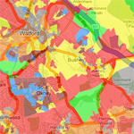
University of Sheffield OAC data site – This site also to give users access to OAC data sets with additional information to aid use. In addition it provides names for clusters in OAC, with pen portraits and photographs to help interpretation. It also has UK maps showing the distributions of Output Areas in particular clusters.
OAC Interactive Map – The OAC super-groups overlaid on Google Earth mapping, which can be viewed interactively.
OAC with digital boundaries via UKBorders (registration required – limited to academic use, however for full details see their site)
OAC with Census data via CASWEB (registration required – limited to academic use, however for full details see their site)
Profile interaction data with OAC via CIDER (registration required – limited to academic use, however for full details see their site)
SASPAC Use OAC within the SAPAC System (subscription required)
Savoy Stewart Commercial estate agents in London Sales data provided for London
The OACUG have created an OAC to Output Area lookup database which can be downloaded [here]. For details on how to use this database see the “Getting Started” section.
Last modified: